Menu

Philippine Standard Time:

Available Mining Properties

Bentonite                                            Silica

Mineral Reservations are established by the President of the Philippines when the national interest so requires, upon the recommendation of the Director of the Mines and Geosciences Bureau (MGB) through the Department of Environment and Natural Resources (DENR) Secretary. The Mineral Reservations were administered by the MGB. However, with the objective of making the mineral reservations revenue-generating, its transfer to the PMDC seems to be the logical direction to take.

The Mineral Reservation projects currently handled by the PMDC are the Diwalwal Gold Mining and Dinagat Chromite-Nickel Mining projects.

Diwalwal Mineral Reservation

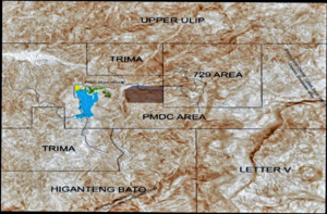
Gold was first discovered in September 1983 by a Lumad, Camilo Banad, along the creeks at Mt. Diwata. With news of the find, a gold rush to the area ensued. In a period of 3 years, the population of Mt. Diwata increased to approximately one hundred twenty-five thousand. The small scale miners lived in shanties along two kilometers of logging road where the gold veins were later exposed.

Unrelenting small scale mining caused adverse effects on the environment. Mercury pollution and siltation of Naboc River waterways and downstream farmlands up to Agusan, was a major problem. Mercury poisoning of workers/residents was prevalent. Thousands died due to accidents, landslides and tunnel cave-ins on account of unsafe working conditions. Underground conflicts among small scale miners caused deaths.

On account of these conditions, the Government on August 12, 2002 declared a state of emergency in Diwalwal. After three months, on November 25, 2002, Proclamation No. 297 declared Diwalwal as a Mineral Reservation. The DENR was granted full control and total management through the Natural Resources Development Corporation (NRDC).

In April 2003, the Natural Resources Mining Development Corporation (NRMDC) was incorporated as the corporate arm of the DENR to engage in mining activities. NRMDC was directed to be attached to the DENR. It was primarily tasked to handle the mining operations of the Diwalwal Project. It undertook an exploration program to determine the remaining reserves of the two major gold veins, after more than 23 years of mining by the small scale miners. Very recently, the name of the company was changed to Philippine Mining Development Corporation (PMDC).

The small scale miners extracted high grade ores in two vein systems, Balite and Buenas-Tinago. They produced approximately 2.7 million ounces during the period and there were never any payment of taxes to the National Government.

The Supreme Court ruled on June 23, 206 that the Executive Branch of the National Government has the full control of the mining operations of the Diwalwal Mineral Reservation. All permits previously issued were deemed as cancelled. This decision paved the way for PMDC to proceed with the development and subsequent mining, directly or with a joint venture partner.

PMDC undertakes the development, promotion and management of various mining projects classified into Mineral Reservations, Privatization Management Office (PMO) Assets, and Cancelled Tenements.

Role of PMDC

The Philippine Mining Development Corporation (PMDC) spearheads the Government’s initiative to develop the 8,100 hectares Diwalwal Mineral Reservation, including, but not limited to, the renowned Diwalwal gold rush area in Mt. Diwata, Compostela Valley.

Located in the southeast portion of the Mindanao Island (figure 1), Mt. Diwata is host to multiple high – grade epithermal – gold vein systems and porphyry copper deposits in the general west direction. The locale, more commonly known as the Diwalwal gold rush area, spans more than two decades of extensive small to medium scale gold production since the early 1980’s, proving the area’s mineralized potential.

Mining operations in the area continued without proper permits and complete disregard of industry standards resulting in pollution, siltation and mercury contamination of the nearby river systems. These adverse effects coupled with violence, threat to public safety and disorder led to the Government’s stoppage order of the mining and mineral processing operations in the Diwalwal gold rush area.

The President approved on November 25, 2002 Proclamation No. 297 – Excluding a certain area from the operations of Proclamation No. 369 dated February 27, 1931, and declaring the same as Mineral Reservation and as Environmentally Critical Area. Approximately 8,100 hectares portion of Agusan – Davao – Surigao Forest Reserve has been segregated for mining activities, mineral processing plants and common tailings disposal system.

PMDC is mandated to conduct exploration and delineation mineral deposits (gold and copper) in the area for direct mining and development by the state. Furthermore, PMDC must ensure the environmental protection of the area by way of constructing the Mabatas Mine Tailings Dam (Interim and Final Dam) to prevent the spill of the effluents and tailings down into the subordinate river systems.

As finalized in the June 2006 Supreme Court Ruling, the State has full control over the mining operations in Diwalwal Mineral Reservation and can pursue full control and supervision of the exploration, development and utilization of the country’s natural mineral resources with two options: 1. Through direct undertaking or by entering into co – production, joint venture, or production – sharing agreements; or 2. By entering into agreement with foreign – owned corporations for large – scale exploration, development and utilization.

Location and Accessibility

The Diwalwal Mineral Reservation is bounded by 7°46’00” to 7°51’00” N latitude and 126°8’00” to 126°13’00” E longitude with a total area of 8,100 hectares. It covers the municipalities of Monkayo, in the Province of Compostela Valley and of Boston and Cateel, Davao Oriental Province.

The designated Small Scale Mining Area under DENR AO 66 is within 7°48’30” to 7°50’00” N latitude and 126°10’30” to 126°12’00” E longitude with a total area of 729 hectares.

The mining area is northeast and can be reached from Davao City by car thru the Davao-Surigao Highway to town of Monkayo, which is about 120 kms; thence eastward from Monkayo via a 22-km unpaved and rough barangay/logging road accessible only with 4-wheel drive vehicles.

Geology

The Mineral Reservation is largely underlain by volcanic sequence made up of volcaniclastics, andesitic volcanic flows, volcanic breccias, and pyroclastics with minor interbeds of sandstone, shale and mudstone. Andesite porphyry and hornblende andesite porphyry intrude this sequence at the northern and southern portions. At the southeast portion, overlying this volcanic sequence is a massive and coralline limestone formation.

Diwata Gold Deposits

The Mineral Reservation is host to the Diwalwal gold vein systems of the Diwata Gold Project, Buenas-Tinago and Balite. These are gold-bearing fissure/breccia veins with massive to sheared, translucent, and dirty white to greenish gray, quartz-calcite and calcite-rich zones. The two vein systems are parallel, about 900m apart, and hosted in volcaniclastics, andesitic volcanic flows and pyroclastics.

Buenas-Tinago Vein

The Buenas- Tinago Vein trends E-W to N45°E and dips 45°-55° to the south. It is truncated by a series of sub-parallel NNE trending strike-slip faults that resulted into an en-echelon vein pattern. The vein consists of white, massive to brecciated, sugary, crystalline, vuggy, crustiform and colloform banded quartz-calcite with slivers of chloritized volcanic host rock. It has widths of 1 to 4 meters with a measured strike length of 925 meters and vertical extent of 254 m from elevation 1000 mast down to 746 masl. It has an average gold grade of 10.93 gpt. The vein system is open-ended to the Northeast and still persists below 746 masl.

Balite Vein

The Balite vein trends E-W to N55°E and dips steeply to the south. The vein ranges in width from 2.5 to 6m and consists of pyritic, white, massive, sugary, crystalline, vuggy and colloform quartz-calcite. Balite vein has a measured strike length of 1.2km and a vertical extent of 450m from elevation 970 down to 525masl. Above L-600 this vein system flares-up, bifurcates, splays and horsetails upward with intervening flexures or dilational jogs, which are usually the loci for bonanza zones. Down-dip at L-570, it forms into a single zone. It has an average gold grade of 9.6 gpt. Reserve is 8 million tons at 8.0 gpt, which will be confirmed by drilling this year.

Gold and Copper Prospects

The Diwalwal gold vein systems are surrounded by copper and gold prospects like Upper Ulip/Matangad Copper-Gold Prospect to the northwest, Mabatas/Higanteng Bato Copper-Gold Prospect the southwest, the Pagasa/Paraiso Gold Prospect to the north, Simulao Gold Prospect to the east, and Mapaso/Letter V/Bermuda Gold Prospects to the south.

Upper Ulip/Matangad Copper-Gold

The Upper Ulip/Matangad Cu-Au Prospect is located 3 kms northwest of Diwalwal. It is defined by a north-south trending 700 meter by 2 km zone with sporadic to extensive quartz stockworks and a possible copper deposit at depth. Quartz veinings and stockworklngs are found on rock outcrops along Upper Ulip and Matangad rivers. Quartz-calcite veinlets have visible copper minerals such as chalcopyrite and bornite. The host rock in the area is chloritic and pyritic andesite porphyry. Malachite and azurite stainings are present on the outcrops in the creek and on the walls of abandoned and active adits in the area. The copper values from the channel cuts ranged up to 0.97% Cu with minimal gold values less than 0.2 ppm. Point samples have copper values of 2.2 to 4.3% and gold values of 0.08 to 0.15 ppm.

Quartz-calcite veinings in the area ranged from 0.5 to 2.7 m in width and trend N-S to NNW and dips 45-85 to the east and west. These quartz veins are white to grey, massive to brecciated, with rhodochrosite, epidote, pyrite, chalcopyrite, sphalerite, bornite and gray silicified, pyritized inclusions. A 2.2 m wide strongly gougy, pyritized-chloritized zone with grey pyritic quartz inclusion has assayed 5.6 ppm Au and 162.18 ppm Cu.

Mabatas I Higanteng Bato Copper-Gold Prospect

The Mabatas/Higanteng Bato Copper-Gold Prospect is located 3kms southwest of Diwalwal. It is defined by a 2.7 km x 3.6 km zone comprising of widespread advanced argillic alteration with associated silica cap/feeder zone-remnants underlain by altered/mineralized hydrothermal breccias in places.Massive silicified outcrops called Higanteng Bato, Asawa HGB and Anak HGB are found to the east and south of the proposed dam. These outcrops are prominent, bare, and 3 to 50 m high above its argillic floor. The outcrops are clay-pyrite-quartz altered, light reddish-brownish at its outer weathered shell and grades into light grayish vuggy, silicified, highly pyritic, and brecciated. Channel-cut sample at the SW comer of the clay-pyrite-silica altered Higanteng Bato yielded up to 1.42 ppm Au and 155.5 ppm Cu.

Several outcrops of altered/mineralized hydrothermal breccias were found at the eastern, western and southern drainage systems of the prospect. The hydrothermal breccia outcrops were essentially silicified, pyritic and with clasts of sub-rounded to sub-angular silicified volcanic rock fragments with micro quartz vein lets, fine pyrite disseminations, minor chalcopyrite and bornite specks. Gold assays from the breccias, which are believed to have been pushed from mineralized porphyry Cu-Au deposit, yielded up to 7.233 ppm Au. Sporadic quartz-clay-pyrite alterations were. Mapped at the western, northern and southern drainage systems of the prospect.

Fregor Gold Prospect

The Fregor Gold Prospect is located near the NRMDC field office, 2kms to the west of Diwalwal. The Fregor Vein, as exposed on the road cut above the portal area showed a 1.4-2.0 m wide fault-vein zone, trends N300E and dips 45°NW towards the Military Camp. It pinches upward and swells downward, with densely developed highly sugary white quartz vein and veinlets along both walls. Fine pyrite dissemination and fault gouge along footwall and hanging wall are likewise noted. Muck grab samples from the Fregor Portal area yielded 1.79 to 7.90 ppm Au.

PAGASA I Paraiso Prospect

The Pagasa/Paraiso prospect is located 1 km to the north of the Diwalwal gold veins. At present, there are several small adits in the area and mining 0.50 to 2 m wide, creamy-white, drusy, pyritic quartz-calcite veins with clay, silicified rock inclusions, manganese oxides and limonite patches. Gold values from these adits ranged up to 4 gpt.

Simulao Gold Prospect

The Simulao Gold Prospect is located 2 kilometers east-northeast of Mt. Diwata. This has been the site of short-lived small-scale gold mining activities in 1987-1988. The gold occurs in pyriticcalcitic quartz veins. Pyrite occurs along the vein walls with rare malachite staining. These EW-ENE vein structures are probably the eastern extensions of Diwalwal vein systems.

Mapaso I Letter V/Bermuda Gold Prospects

These gold prospects are located 1 to 7 kms to the south of the Diwalwal gold deposits. Small scale mining activities are present in these areas. Based on the account of the locals, 0.5 to 2 m wide east-west trending quartz veins are being mined. These quartz veinings may be synchronous with the formation of the Diwalwal gold veins.